
Report: How wildfire models can be enhanced for better preparation and recovery
Dramaguy11 via Getty Images





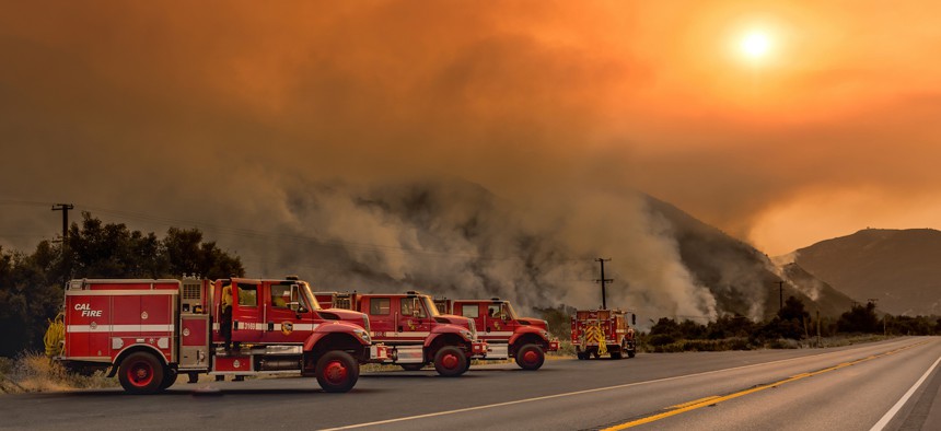
Current models excel at demonstrating wildfires’ behaviors and risk of spreading, but new research identifies key data points that could optimize governments’ planning and preparation for such events.
The growing severity and frequency of wildfires across the U.S. show little signs of slowing down, which is why the scope of wildfire models used to plan and prepare for such disasters must expand too, new research has found.
“[T]he current wildfire modeling ecosystem is strongest in understanding hazard, spread, exposure and structure vulnerability, but becomes progressively less mature as the analysis moves toward consequences, community impacts and operational decision making,” reads a report released late last month from the UL Research Institutes’ Fire Safety Research Institute.
The report findings are based on a review of 28 wildfire risk models representing 21 government agencies, national laboratories, academic organizations, research institutions, nonprofits and the private sector.
“The fundamental issue that we have is local communities across the United States are facing an increased exposure and risk of wildfire … and with that, more communities are having to do things like wildfire risk assessments, engaging in community wildfire protection plans and developing wildfire evacuation plans,” Rebecca Harned, report author and principal research scientist at FSRI, told Route Fifty.
A lack of comprehensive data on wildfires’ impact on local built environments, properties and infrastructure stems from the fact current models broadly focus on urban wildland interfaces away from communities, she explained. Ultimately, this could create potential gaps in how wildfire data inform public safety plans and recovery efforts.
According to the FSRI report, “the most consistent finding across all evaluation groups was the need for models that identify which structures, parcels, neighborhoods and community assets are most at risk,” and that such data could “support resource allocation and risk reduction decisions rather than simply describing fire behavior or hazard conditions.”
Those outputs could help state and local officials implement more specific wildfire solutions within communities, Harned said. For example, wildfire models could be used to identify where to operate chipper programs — or services to dispose of brush, wood and other debris — to reduce the risk of wildfire spread between town lines and natural landscapes.
The infrastructure and financial toll from wildfires are drastic. This year, more than 9.4 million acres of land have burned across the country and 67,640 wildfires have been reported as of last month, according to the National Interagency Fire Center. Plus, an estimated 449,100 buildings across the U.S. could be damaged or destroyed by 2060 by fires without significant interventions.
The cost to recover from wildfires continues to skyrocket for state and local governments. For states at high risk for wildfires — such as California, Colorado and Texas — the projected reconstruction cost value is nearly $1.4 trillion.
More comprehensive models could also identify higher-risk properties in communities, informing officials where to conduct prefire inspections and implement building hardening, like fire resistant roofing, she said.
The report also recommends that wildfire models include more comprehensive exposure modeling, such as fire ember transport, fire spotting and heat transfer between buildings and wildland. Such projections can yield “improved accuracy in estimating structure ignition probability, damage likelihood and community impacts,” the research states.
Other critical factors that wildfire models should incorporate are economic risk analysis and human population dynamics, according to the report.
“Models capable of estimating structure damage probabilities, expected losses, economic consequences, and community-scale impacts were viewed as especially valuable. Such capabilities support prioritization of investments, budgeting decisions, resilience planning and grant allocation,” the report reads.
Additionally, “we can’t underestimate the influence of a community’s population in its resilience to wildfire, and that human dimension is really not accounted for in the majority of models that we reviewed,” Harned said. “Socioeconomic dimensions can really define the capacity that a community has to make the investments needed for [wildfire] mitigation, particularly around their personal property.”
A local population’s financial and demographic standing also “impact the community’s ability to be prepared for an evacuation, whether that’s individuals under the age of 18 or those over the age of 65, identifying transportation-dependent populations, populations of people that are depending on oxygen or with certain medical limitations in nursing homes,” Harned said.
“We have to understand those dynamics, and that needs to be accounted for as part of how we measure risk and use that information to inform our planning and mitigation,” she said.
Broader improvements to wildfire models include developing interoperability and shared data frameworks across different tools available to state and local officials “to build a federated modeling ecosystem that enables collaboration, model integration and workflow automation,” the report reads.
The findings also suggest enhancing data visualizations, communication and explainability of wildfire models to ensure they are usable to a general population in addition to data or technical experts.
Ultimately, improving the data sources and structure of wildfire models serves as an “important bridge between something as technical as modeling science into real, practical decisions that local communities really have to make today across the United States,” Harned said.