The Geography of Disaster Risk and Resiliency in America: Alaska
StartIn “The Geography of Disaster Risk and Resiliency in America,” a series of Route Fifty dispatches that will be part of a larger forthcoming ebook, I’m featuring locations that provide snapshots of the very real dangers and disruptions that emergency planners, first responders, public officials and other stakeholders face, plus the strategies and technologies helping our communities be more resilient.
I’m starting in Alaska and will be heading into the Pacific Northwest. Since this part of the United States sits on the Pacific “Ring of Fire,” there will be many stories about volcanoes, earthquakes and tsunamis. But it’s also about landslides, flooding, wildfires, nuclear waste, sewage treatment and the continuity of government during a crisis.
I even hiked on top of a recent avalanche in Juneau, the U.S. city most at risk for urban avalanches. Join me for my explorations of disaster risk and resiliency in the 49th State.
— Michael Grass
Executive Editor
Route Fifty | Government Executive Media Group1/6
Anchorage: Lessons From Earthquake Park
ANCHORAGE — It’s a natural landscape unlike I’ve ever—and I suspect you’ve ever—encountered. Large and angular chunks of land pushed up in a confusing manner, with birch and spruce trees and other vegetation growing up and out of the ground fractures.
It’s a bright and warm mid-April evening and there’s still some snow on the ground, but not too much to prevent me from exploring an unusual municipal park. Pools of water, some iced over, make navigating the fractured land challenging.
(Photo by Michael Grass / Route Fifty) If you didn’t know you were in a place called Earthquake Park, you might not necessarily realize you’re in a landscape that was radically and suddenly reshaped in the span of five minutes during a massive disaster more than 50 years ago.
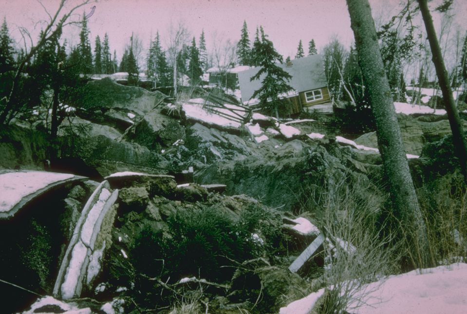
The Turnagain Heights neighborhood sustained significant damage during the 1964 earthquake. (Courtesy NOAA National Geophysical Data Center) During the magnitude 9.2 Good Friday Earthquake on March 27, 1964, the largest seismic event ever recorded in North America, part of Anchorage’s Turnagain Heights neighborhood was destroyed when a bluff deteriorated and slid toward Cook Inlet, a few miles from downtown.The land here dropped as much as 40 feet and slid as far as 2,000 feet away from its original location.
(Photo by Michael Grass / Route Fifty) For being so large, that megaquake and tsunami only killed 139 people thanks to Alaska’s low population density. But it shows just how ferocious and destructive the forces of nature can be.
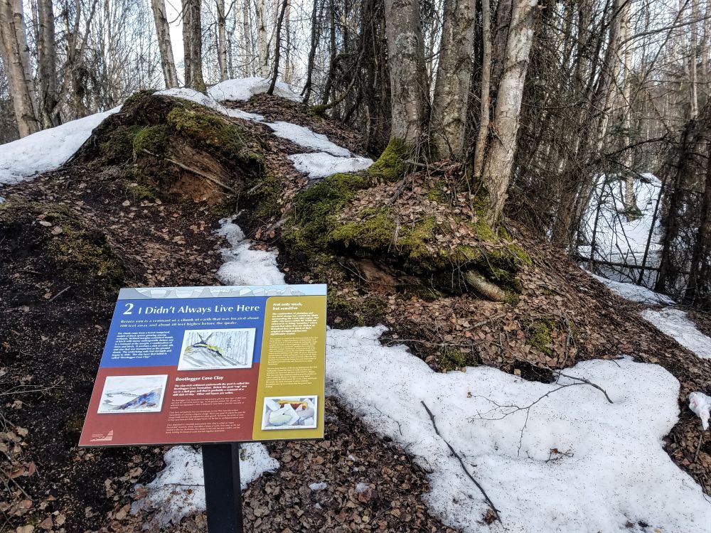
Following the 1964 disaster, the municipality left the land that would become Earthquake Park as is to be reclaimed by nature. An interpretive side trail, with detailed signs explaining how and why the ground failed, allows you to better appreciate the reality that the ground we stand on is not always stable.
It also serves as a reminder that disasters big and small can strike without warning and that state and local governments, working with federal partners and community stakeholders, have to be ready to respond.
— Michael Grass
2/6
Port of Anchorage: Alaska’s Vulnerable Supply Lifeline
ANCHORAGE — While Anchorage and the rest of southern Alaska would recover from the 1964 Good Friday earthquake, it won’t necessarily take a disaster of the same size and scope to cause major hardship again.
“We are one small earthquake away from a major disaster,” according to Mayor Ethan Berkowitz, in this video produced by Cities of Service, a Bloomberg Philanthropies program which has been working on resiliency issues in Alaska’s most populous municipality, specifically food security. Anchorage is one of 10 cities participating in the Resilience AmeriCorps program.
About 90 percent of Alaska’s goods come into the state through the Port of Anchorage, which relies on an aging and corroding pier that sits atop pilings that are now 30 percent of their original wall thickness. There’s a modernization effort underway. But Anchorage and most of the state will have to rely on Band-Aid repairs until a replacement pier is fully funded and built.
“We’re incredibly dependent on logistics to make sure that we get our food here in Anchorage. We have food supplies on the shelves of three to four days. If there’s a disruption. We have a major problem,” Berkowitz says in the video.
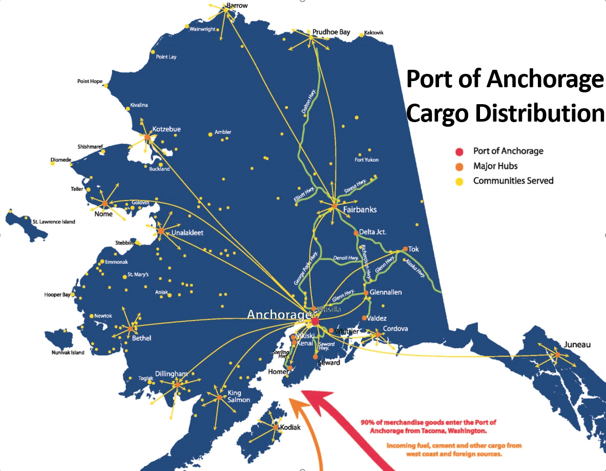
(Courtesy Port of Anchorage) 3/6
Anchorage: Neighborhood Resiliency and Food Security
ANCHORAGE — Driving around Alaska's most populous municipal jurisdiction, community gardens and backyard greenhouses are not unusual features to see. They're one way local residents can bolster their food security.
“Alaska Grown” isn’t just a source of local pride, it’s a reminder of the necessity to cultivate local food sources when when you live in an isolated place that regularly experiences major earthquakes and volcanic eruptions, in addition to often cold and bitter winters.
Anchorage’s Mountain View neighborhood, which is home to the most diverse census tract in the nation, has been an area of focus for the municipal government due to its high unemployment and higher percentage of residents who don’t have access to a personal vehicle.
Cross-sector collaborations in Anchorage have focused on community development and resiliency issues in Anchorage
Cities of Service, for instance, has worked with Mountain View Elementary School to build a community greenhouse, a collaboration that’s helped educate children about the importance of cultivating local food sources.
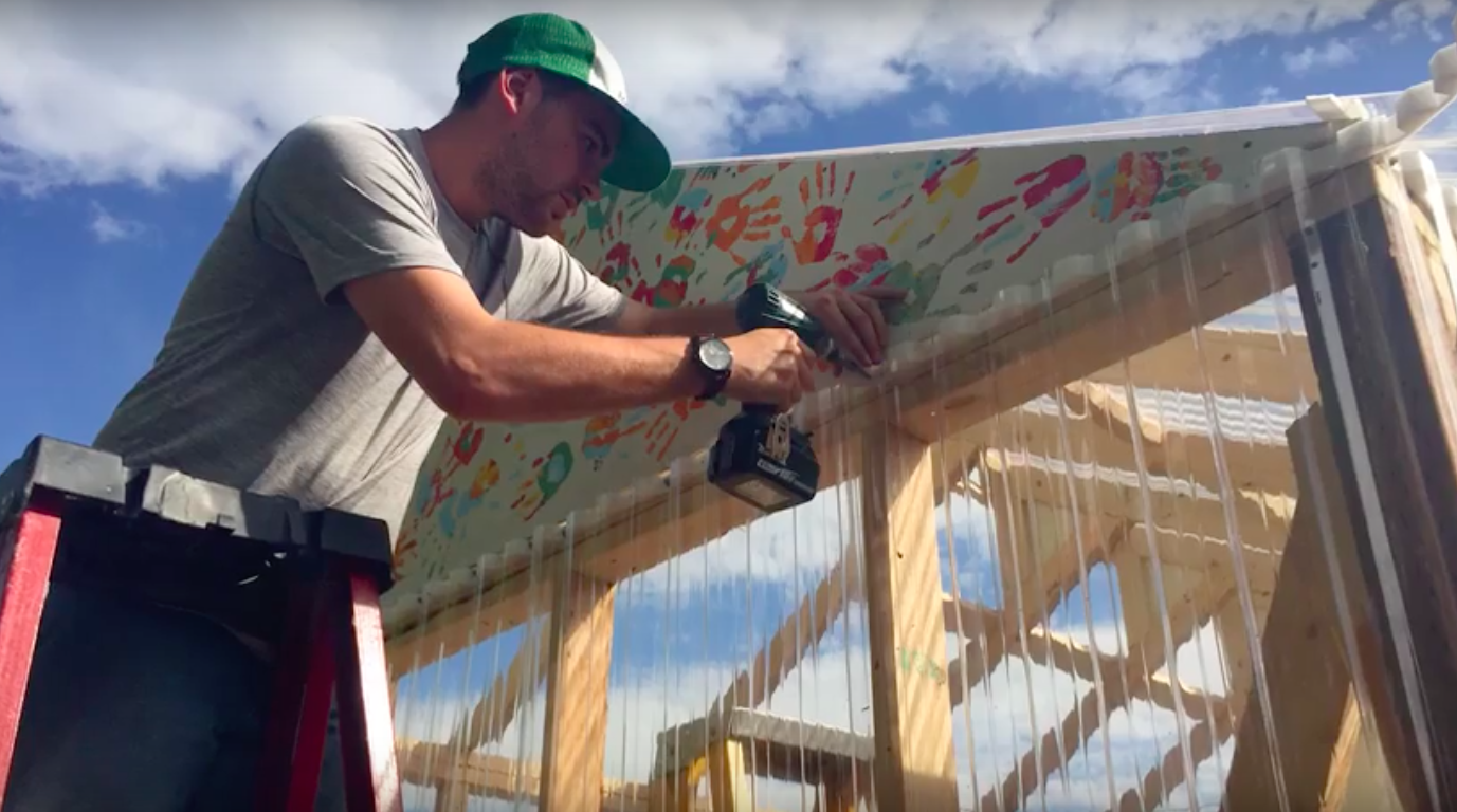
(via Cities of Service video) A neighborhood farmers market, which launched last year on a two-acre property along Mountain View Drive controlled by the Anchorage Community Land Trust, has become an area of focus for community development as well.
Anchorage is one four U.S. cities the Daniel Rose Center for Public Leadership is working with this year in its annual fellowship program, along with Grand Rapids, San José and Washington, D.C. Each city is working on its own land-use challenge and in Anchorage, much of the Rose Center’s work is focused on Mountain View and better leveraging the farmers market site as a “community hub and garden” while building better, more walkable connections with neighborhood assets, including a new health clinic, grocery store, boys and girls club, middle school and library.
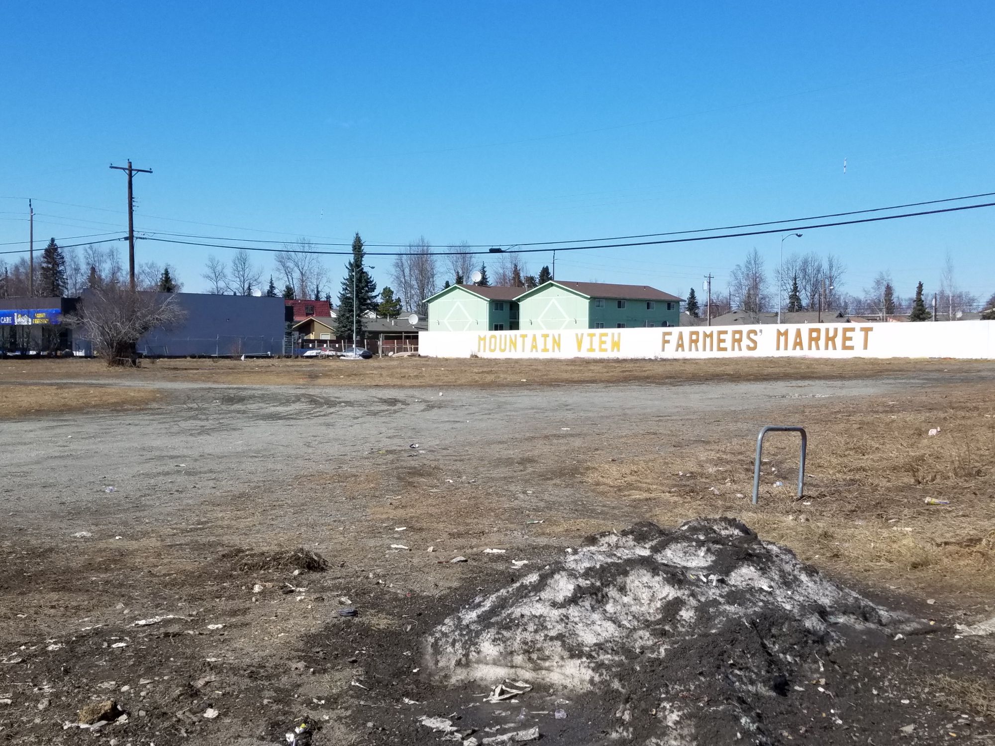
The Mountain View Farmers Market site (Photo by Michael Grass / Route Fifty) When building a more resilient community, you often think of strengthening physical infrastructure to withstand natural disasters and disruptions. But as the work to make Mountain View and Anchorage more resilient shows, it also means about strengthening the ability of the community to help sustain itself the next time Alaska’s primary port is knocked offline.
— Michael Grass
4/6
Portage: A Town That Sank and (Mostly) Disappeared
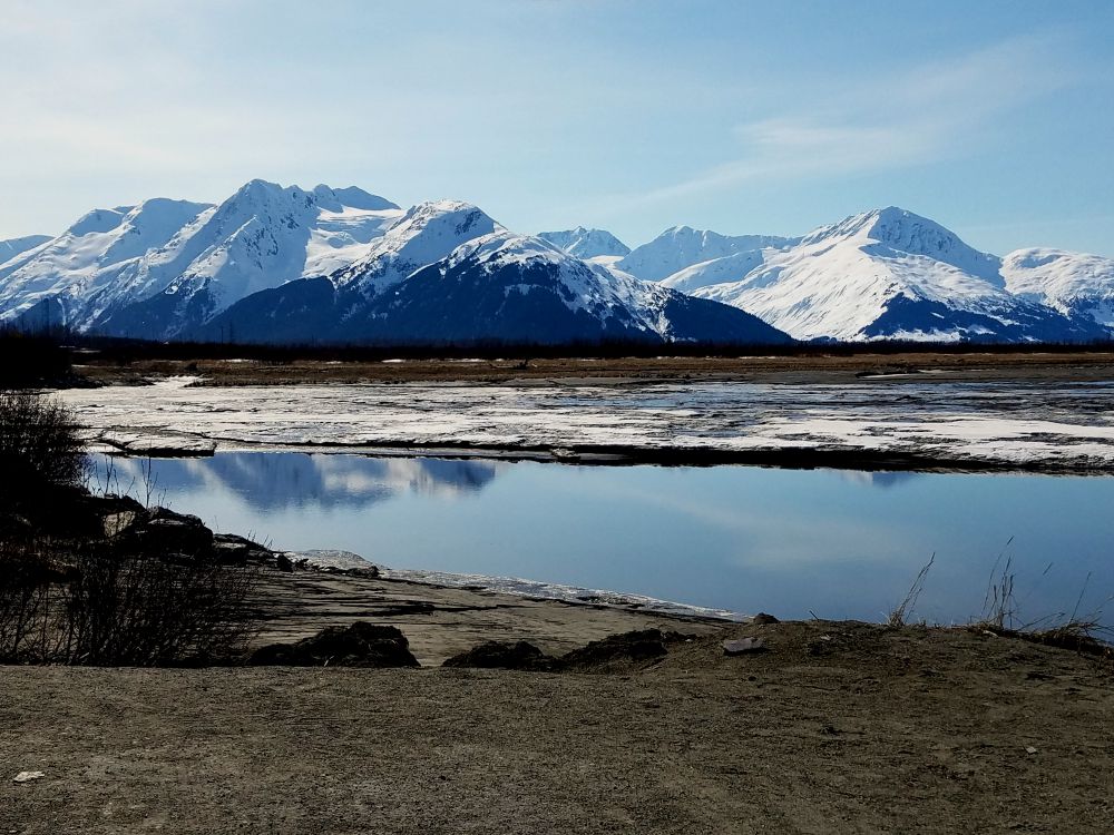
PORTAGE, Alaska — Driving along the Seward Highway south from Anchorage, there’s a lot of stunningly beautiful scenery to look at going by out the window. Snowcapped mountains flank Turnagain Arm, a narrow waterway that separates most of the Kenai Peninsula from the North American continent. There are plenty of turnouts to stop and take photos.
At the far eastern end of that waterway, the Seward Highway makes a big U-turn curve crossing the vast mudflats where the Twentymile River, Placer River and Portage Creek meet saltwater.
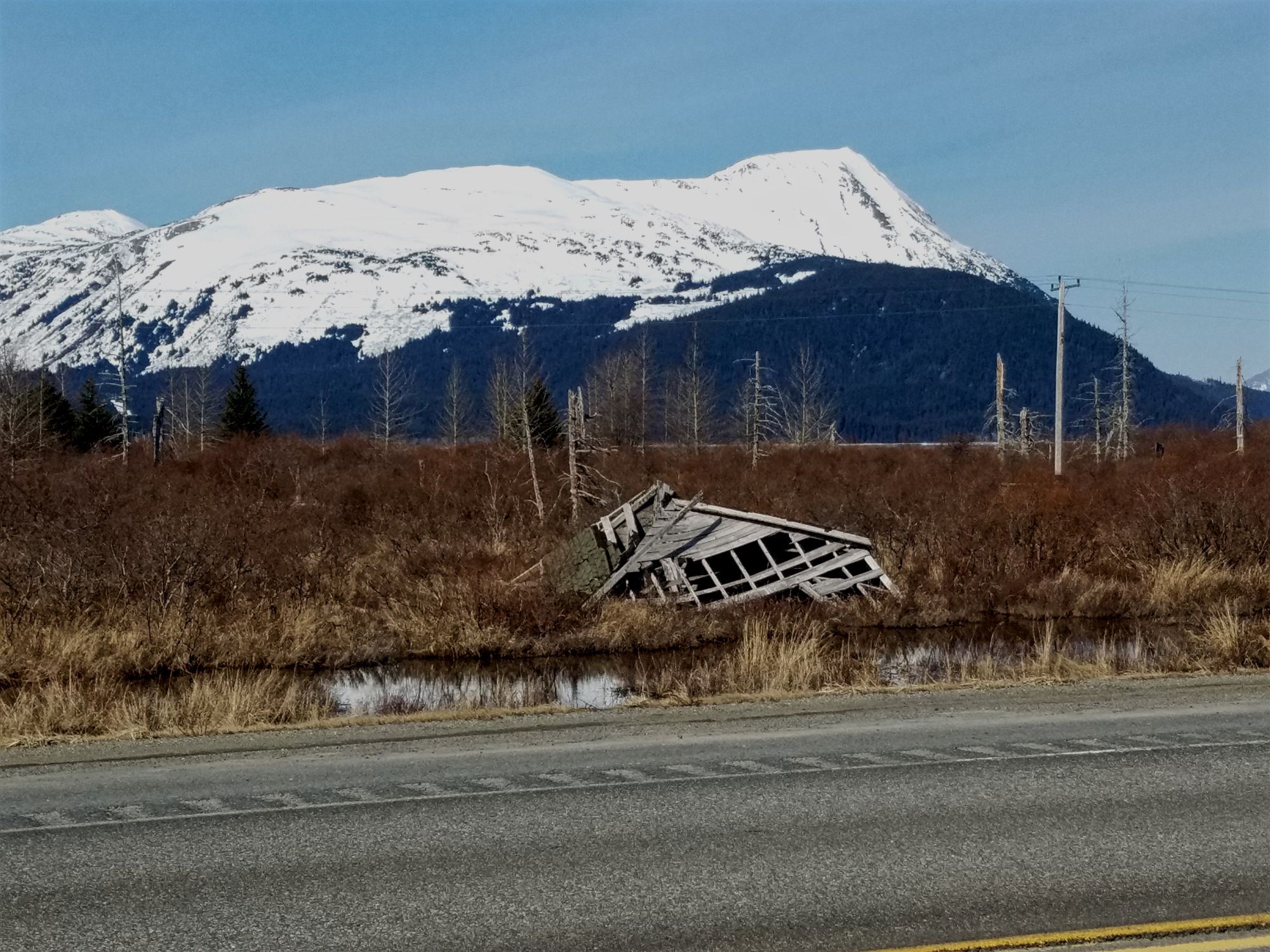
What's left of Portage, Alaska (Photo by Michael Grass / Route Fifty) Off in the distance, you can see the Whittier and Portage glaciers up in the mountains. But closer to the water level, you might be able to see the legacy of North America’s largest-recorded earthquake while zooming by at 55 mph.
This is where the settlement of Portage once stood. On March 27, 1964, the magnitude 9.2 Good Friday Earthquake struck south central Alaska, devastating the 49th State’s most populous region.
While Portage was never a large town, it was an important junction for transporting goods and services between Whittier, a port on an arm of Prince William Sound, and some of the local mining settlements that began to pop up in the 1890s.
Portage once stood where the Twenty-Mile River meets Turnagain Arm. (Photo by Michael Grass / Route Fifty) But that important junction sat on soft soils that not only liquefied during the quake, but also sank about 8 to 10 feet in the process, which took less than five minutes.
According to this account of the earthquake’s impacts on Portage:
An eyewitness who was in a service station on the west side of the highway said he and a companion ran out the east door of the building as the concrete floor began to crack. They got about three feet out of the building when a crack about three feet wide opened between them. He said that cracks formed about each of them, leaving each man on a small island about three feet wide that moved up and down. He said it was like riding an open elevator. As he went down, the other man went up. And then they’d pass each other going in opposite directions. He said that the earth all around them broke into similar pieces and that as the blocks of frozen earth moved up and down, the cracks also opened and closed causing muddy water to spout as high as 50 feet. He said after the shaking stopped, water filled the open cracks.
Today, you can still see the remains of a few buildings going by on the Seward Highway.
Additionally, there are also “ghost” forests—ashen-looking tree trunks that rise out of the marsh and mud. When the ground sank, the root systems were exposed to saltwater, killing the trees.
While Portage wasn’t totally erased by the quake, it was submerged at high tide and had to be abandoned. In the recovery from the quake, Alaska had to raise a portion of the Seward Highway, which sank into the mudflats along with Portage.
Fifty-three years after the Good Friday earthquake, this unusual corner of Alaska is a reminder about just how vulnerable certain places can be for human habitation, and how quickly they can vanish from view.
— Michael Grass
5/6
Icy Bay: A 2005 Megatsunami That Nobody Saw
If the massive 1964 Good Friday earthquake wasn’t enough to demonstrate the power of disasters in Alaska, you should take a flight between Anchorage and Juneau and hope to have a window seat with a good view and clear weather.
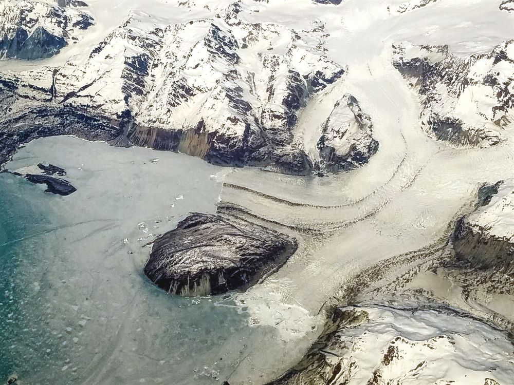
Flying over the rugged and icy landscape of Southeastern Alaska. (Photo by Michael Grass / Route Fifty) The stunningly beautiful mountains, glaciers, ice fields and fjords along Alaska’s southeastern coast are visually impressive from above. This stretch of territory has been home to the largest tsunamis ever recorded. They’re not just tsunamis—they’re megatsunamis.
In 1958, a large earthquake near Lituya Bay, with a 9.2 magnitude, triggered a rockslide which sent a 40 million cubic yards of rock downward into the narrow inlet, creating a localized wave so high that it removed vegetation up to 1,720 feet in elevation. (For comparison, that’s almost as tall as One World Trade Center in lower Manhattan.)
The Lituya Bay wave, thanks to the area’s constrained geography and the size of the rockslide, was the tallest tsunami ever recorded on the planet.
On Oct. 17, 2015, a similar type of wave, though not as tall, was created from a landslide in Taan Fjord, an arm of Alaska’s Icy Bay. The wave scraped away forests and vegetation along the inlet’s steep shores up to point that was 600 feet above sea level. But that wave, roughly the same height as the Space Needle in Seattle, initially went unnoticed because the rugged region, part of the Wrangell-St. Elias Wilderness, is mostly uninhabited and the wave dissipated about 8 miles out into open water, stopping a few miles short of the remote Icy Bay Lodge.
As Atlas Obscura wrote in March, the landslide was detected on the other side of the continent at Columbia University’s Lamont-Doherty Earth Observatory, located north of New York City. That remote detection prompted further investigation, which led to the megatsunami’s detection.
“There are not that many landslide detections by us in a given year, maybe just half a dozen,” researcher Göran Ekström told Atlas Obscura. “We now know that when we detect something, it is often spectacular. We had just detected another landslide in the Yukon a week earlier, and had it confirmed, so I was quite excited when I saw another detection in the Saint Elias range, especially since it was not detected by anyone else, and because it was so large.”
There are worries that as climate change warms the planet, the continued melting of glaciers and ice fields, like those in Alaska, will lead to more landslides—and potentially, large localized megatsunamis.
Oftentimes, tsunamis are generated by large offshore earthquakes with epicenters in subduction zones. The distance between those earthquakes and a vulnerable coastline is often large enough where there can be—if such an event is immediately detected—enough time to evacuate people out of harm’s way.
But when localized megatsunamis like those that took place at Icy Bay and Lituya Bay happen, there’s not essentially no time to get out of the way. Facing a rapidly moving wave that is hundreds of feet high—or perhaps even more than 1,000 feet high—is a scenario where emergency managers have essentially have no options to immediately react and respond.
It’s an awesome force of nature—and fortunately a rare one.
— Michael Grass- Start Over
6/6
Juneau: Living With the Risk of Urban Avalanches
JUNEAU, Alaska — In late March, the Last Frontier’s remote and isolated capital city briefly made national headlines thanks to a dramatic cellphone video that captured an avalanche in progress.
But the large mass of snow and ice wasn’t tumbling down a steep slope in some remote and rugged backcountry. It hit the fringes of Juneau’s population center, about a 10-minute walk from the State Capitol.
Fortunately, the avalanche that came down from Mount Juneau, which reaches an elevation of nearly 3,600 feet above sea level, missed hitting any homes. But it came close.
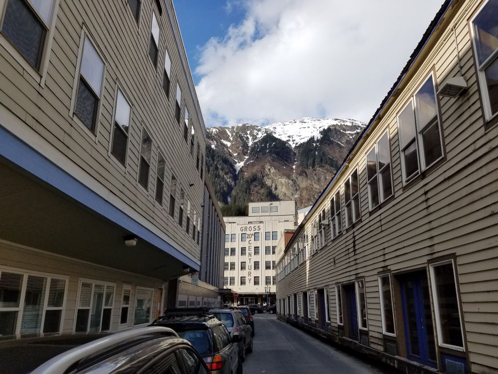
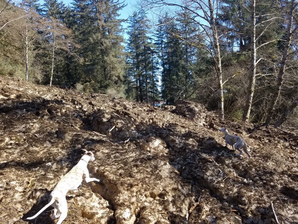
Downtown Juneau sits at the foot of Mount Juneau. (Photo by Michael Grass / Route Fifty) I saw this first hand about two weeks after the avalanche, with a local resident who lives near the end of Coleman Street and showed me around while walking her dogs.
After hiking up a short trail from the dead-end street, there it was, a dirty, icy mass blocking the path, which is used by mountain bikers and neighborhood residents alike.
The avalanche’s sloping remains had decreased in size since it had come down the mountain, but it was about as high as a one-story house. The avalanche video, which features a white cloudy cascade of powder, might suggest a somewhat benign force of nature.
But traversing the avalanche’s remains, the reality isn’t anything to scoff at—it was mostly cragged hard-packed ice, covered in dirt, rocks, uprooted trees and destroyed vegetation that had been carried down the slope.
The remains of the March 31 avalanche near downtown Juneau about two weeks following the event. (Photo by Michael Grass / Route Fifty) Juneau escaped a potentially tragic incident that early spring day, but it could have been deadly if the circumstances had been different.
Avalanches can be deadly when they strike inhabited areas. In January, 29 people were killed at an Italian ski resort when it was buried by an avalanche believed to have been triggered by a nearby earthquake.
Alaska’s capital city has long lived with the risk of avalanches. In fact, Juneau is the U.S. city at most risk for urban avalanches. Fortunately, the dangers have not been ignored and the vulnerable areas are all mapped.
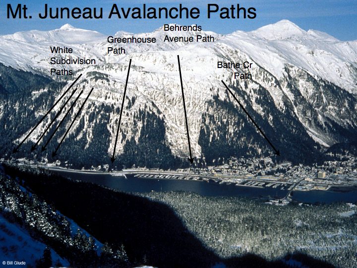
(via City and Borough of Juneau) 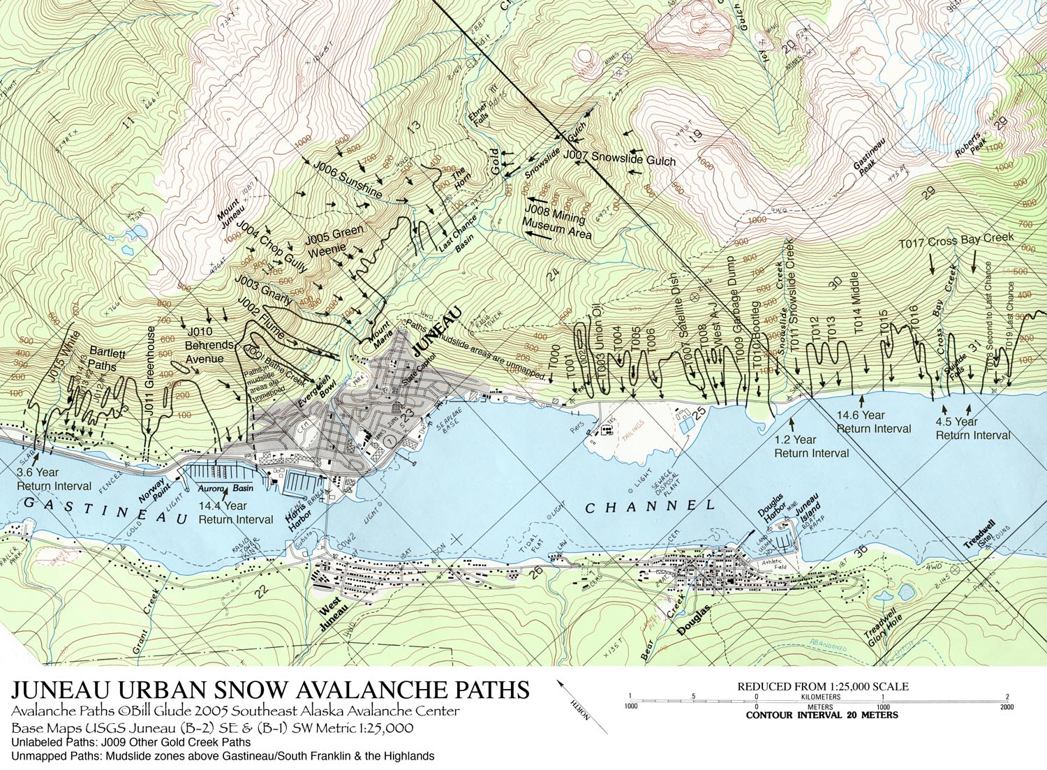
(via USGS / City and Borough of Juneau) The March 31 avalanche came down in what’s called the Behrends Avenue slide path, where there’s a residential area at risk for avalanche damage.
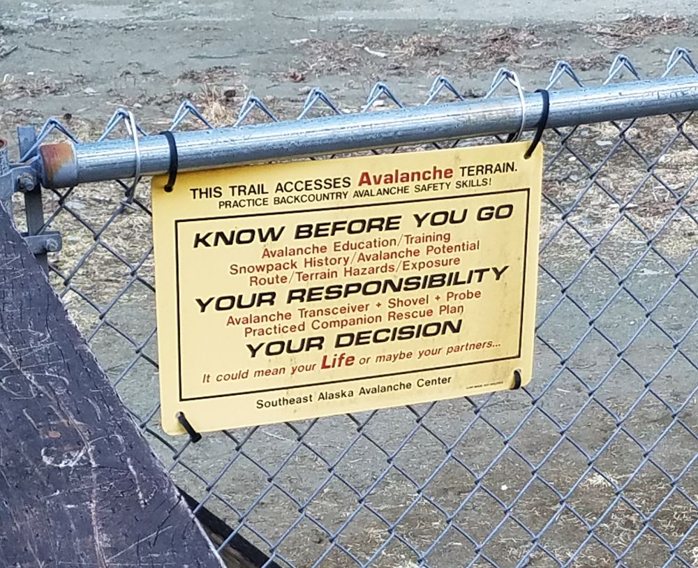
The popular (and scenic) Gold Creek Flume recreational trail, which also sits in the shadow of Mount Juneau, is also at risk. Signs are there to remind residents of the danger and their responsibility to understand the risks.
(Photo by Michael Grass / Route Fifty) In late December, an avalanche came down Mount Juneau above the Gold Creek Flume trail. It too was captured on video, which was shared on Facebook, but ended up being smaller than it initially appeared.
“It’s always impressive because it’s a big powder cloud. That’s a thousand foot cliff so it just comes straight down and turns into air, so even small avalanches look very, very large,” Tom Mattice, emergency programs manager for the City and Borough of Juneau, told the Juneau Empire newspaper at the time.
This past winter, the snowpack level on the mountains surrounding downtown Juneau was not particularly high, so the overall avalanche danger was low.
But, as Mattice told the newspaper: “Low danger doesn’t mean no danger, and if you’re going into the mountains, you always need to be thinking of safety.”
Avalanche risk can vary depending on local terrain, the amount of snowpack, weather conditions and the way layers of snow and ice accumulate and melt. Complicating matters is the quick transition from a warmer maritime weather conditions at lower elevations—where most of Juneau’s residents live—to colder conditions on the mountains that surround the city.
During months of greatest risk—November to March—the City and Borough of Juneau issues avalanche advisories and works with the volunteer-driven non-profit Southeast Alaska Avalanche Center, which promotes mountain safety through forecasting, rescue training and education.
Thane Road, which runs for nearly six miles from downtown Juneau along the Gastineau Channel until it ends—there are no roads connecting Juneau to the rest of the North American continent—is at particular risk for avalanches.
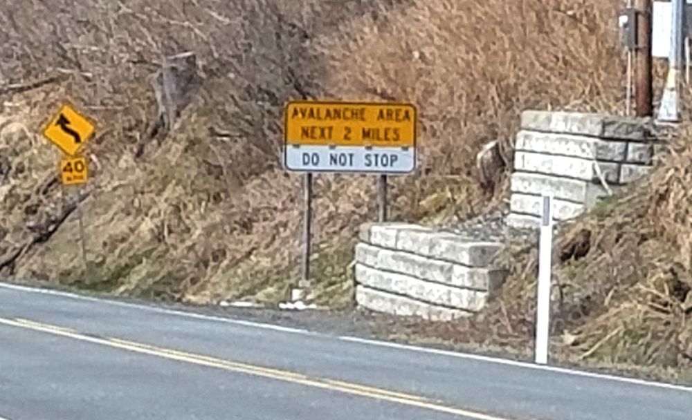
Along Thane Road, which crossed an avalanche zone. (Photo by Michael Grass / Route Fifty) Warning signs along the road mark the danger zone, where stopping is discouraged. During the winter months, local authorities do avalanche mitigation work along Thane Road, using a 105 mm howitzer on loan from the U.S. Army that shot from across the channel on Douglas Island.
When that road is closed by an avalanche or avalanche mitigation work, an entire neighborhood is cut off from the rest of Juneau. Even more, power lines connecting Juneau to an important hydroelectric source are at risk of being severed, too.
Urban avalanches are a disaster risk few U.S. cities have to deal with, but Juneau is place that has had learn to co-exist with the danger. With the risk clearly in view looming above the city, it's had no choice.
— Michael Grass
Do Not Sell My Personal Information
When you visit our website, we store cookies on your browser to collect information. The information collected might relate to you, your preferences or your device, and is mostly used to make the site work as you expect it to and to provide a more personalized web experience. However, you can choose not to allow certain types of cookies, which may impact your experience of the site and the services we are able to offer. Click on the different category headings to find out more and change our default settings according to your preference. You cannot opt-out of our First Party Strictly Necessary Cookies as they are deployed in order to ensure the proper functioning of our website (such as prompting the cookie banner and remembering your settings, to log into your account, to redirect you when you log out, etc.). For more information about the First and Third Party Cookies used please follow this link.
Manage Consent Preferences
Strictly Necessary Cookies - Always Active
We do not allow you to opt-out of our certain cookies, as they are necessary to ensure the proper functioning of our website (such as prompting our cookie banner and remembering your privacy choices) and/or to monitor site performance. These cookies are not used in a way that constitutes a “sale” of your data under the CCPA. You can set your browser to block or alert you about these cookies, but some parts of the site will not work as intended if you do so. You can usually find these settings in the Options or Preferences menu of your browser. Visit www.allaboutcookies.org to learn more.
Sale of Personal Data, Targeting & Social Media Cookies
Under the California Consumer Privacy Act, you have the right to opt-out of the sale of your personal information to third parties. These cookies collect information for analytics and to personalize your experience with targeted ads. You may exercise your right to opt out of the sale of personal information by using this toggle switch. If you opt out we will not be able to offer you personalised ads and will not hand over your personal information to any third parties. Additionally, you may contact our legal department for further clarification about your rights as a California consumer by using this Exercise My Rights link
If you have enabled privacy controls on your browser (such as a plugin), we have to take that as a valid request to opt-out. Therefore we would not be able to track your activity through the web. This may affect our ability to personalize ads according to your preferences.
Targeting cookies may be set through our site by our advertising partners. They may be used by those companies to build a profile of your interests and show you relevant adverts on other sites. They do not store directly personal information, but are based on uniquely identifying your browser and internet device. If you do not allow these cookies, you will experience less targeted advertising.
Social media cookies are set by a range of social media services that we have added to the site to enable you to share our content with your friends and networks. They are capable of tracking your browser across other sites and building up a profile of your interests. This may impact the content and messages you see on other websites you visit. If you do not allow these cookies you may not be able to use or see these sharing tools.
If you want to opt out of all of our lead reports and lists, please submit a privacy request at our Do Not Sell page.
Cookie List
A cookie is a small piece of data (text file) that a website – when visited by a user – asks your browser to store on your device in order to remember information about you, such as your language preference or login information. Those cookies are set by us and called first-party cookies. We also use third-party cookies – which are cookies from a domain different than the domain of the website you are visiting – for our advertising and marketing efforts. More specifically, we use cookies and other tracking technologies for the following purposes:
Strictly Necessary Cookies
We do not allow you to opt-out of our certain cookies, as they are necessary to ensure the proper functioning of our website (such as prompting our cookie banner and remembering your privacy choices) and/or to monitor site performance. These cookies are not used in a way that constitutes a “sale” of your data under the CCPA. You can set your browser to block or alert you about these cookies, but some parts of the site will not work as intended if you do so. You can usually find these settings in the Options or Preferences menu of your browser. Visit www.allaboutcookies.org to learn more.
Functional Cookies
We do not allow you to opt-out of our certain cookies, as they are necessary to ensure the proper functioning of our website (such as prompting our cookie banner and remembering your privacy choices) and/or to monitor site performance. These cookies are not used in a way that constitutes a “sale” of your data under the CCPA. You can set your browser to block or alert you about these cookies, but some parts of the site will not work as intended if you do so. You can usually find these settings in the Options or Preferences menu of your browser. Visit www.allaboutcookies.org to learn more.
Performance Cookies
We do not allow you to opt-out of our certain cookies, as they are necessary to ensure the proper functioning of our website (such as prompting our cookie banner and remembering your privacy choices) and/or to monitor site performance. These cookies are not used in a way that constitutes a “sale” of your data under the CCPA. You can set your browser to block or alert you about these cookies, but some parts of the site will not work as intended if you do so. You can usually find these settings in the Options or Preferences menu of your browser. Visit www.allaboutcookies.org to learn more.
Sale of Personal Data
We also use cookies to personalize your experience on our websites, including by determining the most relevant content and advertisements to show you, and to monitor site traffic and performance, so that we may improve our websites and your experience. You may opt out of our use of such cookies (and the associated “sale” of your Personal Information) by using this toggle switch. You will still see some advertising, regardless of your selection. Because we do not track you across different devices, browsers and GEMG properties, your selection will take effect only on this browser, this device and this website.
Social Media Cookies
We also use cookies to personalize your experience on our websites, including by determining the most relevant content and advertisements to show you, and to monitor site traffic and performance, so that we may improve our websites and your experience. You may opt out of our use of such cookies (and the associated “sale” of your Personal Information) by using this toggle switch. You will still see some advertising, regardless of your selection. Because we do not track you across different devices, browsers and GEMG properties, your selection will take effect only on this browser, this device and this website.
Targeting Cookies
We also use cookies to personalize your experience on our websites, including by determining the most relevant content and advertisements to show you, and to monitor site traffic and performance, so that we may improve our websites and your experience. You may opt out of our use of such cookies (and the associated “sale” of your Personal Information) by using this toggle switch. You will still see some advertising, regardless of your selection. Because we do not track you across different devices, browsers and GEMG properties, your selection will take effect only on this browser, this device and this website.