GPS finds its place


Location, location, location. Nearly every action a government organization takes can be tied to a map. Whether it's a military commander following troop movements, a biologist tracking the migration of an endangered species of bird or a legislature drawing new district lines after the census, the task can be enhanced by readily accessible and precise geographical data.
By Drew RobbSpecial to GCNLocation, location, location. Nearly every action a government organization takes can be tied to a map. Whether it's a military commander following troop movements, a biologist tracking the migration of an endangered species of bird or a legislature drawing new district lines after the census, the task can be enhanced by readily accessible and precise geographical data.Government's fascination with geographic data is by no means a recent phenomenon. Early European navigators set sail in search of the International Date Line believing that the nation that discovered how to determine longitudes would rule the seas. George Washington learned the surveying craft as a youth, lugging iron measuring rods around the Virginia back country.Following in the first president's footsteps, the federal government has employed the Lewis and Clark expedition, the Geological Survey and the Army Mapping Office to determine the extent and nature of its expanding territory. Later came a network of radio navigation beacons, aerial mapping and, most recently, the Defense Department's Global Positioning System.GPS was created to meet the military's need for more precise location information. It was intended for defense purposes, but in 1983 President Reagan ordered that it be made freely available worldwide for commercial use. The system consists of three basic elements: satellites, ground-based control centers and user receivers.The first GPS satellite was launched in 1978, and by 1994, a network of 24 satellites surrounded the globe. They orbit every 12 hours, stationed 11,000 miles above the Earth.In total, there are six orbital planes, each containing four satellites. This provides between five and eight visible satellites at any point on Earth. On board each satellite are four atomic clocks, a communications receiver and a transmitter. Each satellite emits a continuous signal containing its exact location and time.The satellites are controlled by a system of tracking stations around the world. The Master Control facility is at Schriever Air Force Base, Colo., home of the Air Force's 50th Space Wing, which provides command and control for Defense warning, navigational and communications satellites. Additional unmanned monitoring stations are located in Hawaii and Kwajalein in the Pacific Ocean, Diego Garcia in the Indian Ocean and Ascension in the Atlantic. These stations monitor and control the satellites and provide information to correct errors in the time and position signals sent out by the satellites.The final part of the system is the user segment. There are hundreds of different types of GPS receivers. The basic elements are a receiver tuned to satellite signals, a processor, software to decode and analyze the signals, and a user interface designed for the specific application. They include everything from those used in jumbo jets and missiles, to boats and cars, to surveying equipment and a recent release of a GPS attachment for a Palm V handheld computer from Palm Inc. of Santa Clara, Calif.For a GPS receiver to determine its position, it needs to receive signals from at least three satellites, preferably more. It takes the time data received from a satellite and, by comparing it with its internal clock, knows how long it took the signal to reach it. It then converts the time into distance and knows how far away it is from the position transmitted by the satellite. By analyzing the data from three or more satellites, the receiver triangulates its position.There are two signals sent out by the satellites: Precise Positioning Service (PPS) and Standard Positioning Service (SPS). Civilian users get SPS, a signal that is less accurate than it could be because of a Defense measure to keep accurate data from hostile parties. The SPS signal is degraded using what is called selective availability, so that it only provides 100-meter horizontal and 156-meter vertical accuracy.PPS, on the other hand, has 22-meter horizontal and 22.7-meter vertical accuracy. The level of accuracy is restricted to authorized users'U.S. and allied military organizations and selected U.S. agencies'with cryptographic equipment and keys, as well as specialized receivers. The PPS system also increases its accuracy by using a second carrier wave that allows receivers to measure the delay caused by the signals moving through the ionosphere.Although Defense tries to limit the accuracy of commercially available GPS systems, there are now systems that can pinpoint location to within a centimeter.The first major improvement came from the Coast Guard. The technique, called Differential GPS, uses a series of base stations.Since the exact position of the base stations is known and unchanging, it can take the data coming from the satellite signals, compare it with the base station's known position and calculate corrections to the signal error.The corrections are then broadcast through a network of radio beacons along the coastline. Remote receivers take these corrections and apply them to the GPS signals they are receiving and achieve an accuracy of 1 to 10 meters.Differential Carrier GPS is another method used in surveying, achieving accuracy that is measured in millimeters. It requires a reference base station and a remote receiver tracking the same signals at the same time. Distance between the two units is measured using the phase of the carrier signal.To ensure accuracy, the units must be close enough so that the ionospheric delay difference between the two stations is less than one carrier wavelength, generally within 16 miles. A newer technique called real-time kinematic processing allows measurements accurate to 1 centimeter while the remote receiver is in motion.Ashtech Inc. also has developed surveyors that use data from the Russian Space Forces' Global Navigation Satellite System in addition to GPS. This increases accuracy because of the greater number of satellites available for triangulation calculations. GLONASS signals also are not subject to the same intentional degradation as GPS signals.GPS receivers for cars and other vehicles use dashboard gyroscopes and sensors in the wheels that provide information on location, speed and bearing even when GPS signals are blocked by tall buildings or when driving in a tunnel. Such systems can achieve accuracy within a meter.Although a GPS can pinpoint a user's location, it does not tell whether that location is in the Oval Office or at the bottom of the Pacific.That data must be correlated with geographic information system data for it to be useful. Bearing and velocity can also be vital for airplanes, missiles, cars and other vehicles.The most basic function is to relate this data to a digital mapping program that can identify a position on a map and detail what else is around it. The Geographic Resources Analysis Support System GIS, for example, was developed by the Army Corps of Engineers for military land management and environmental planning.It has expanded beyond its original purpose and is now used by NASA, the National Oceanic and Atmospheric Administration, the National Park Service, the Census Bureau, the Coast Guard and other agencies, as well as academic and commercial establishments. It is available at no cost from a site hosted by Baylor University, at , and there are mirror sites around the world.GRASS is a Unix system using an X Window graphical user interface. GRASS 5.0 Beta 7 was released in April and is compatible with Solaris, Linux and SGI Irix.Rand McNally and Co. () is the most popular supplier of commercially available mapping programs. It has GPS software with either topographical data or street data for driving use, including its StreetFinder Deluxe 2000.'It has a GPS receiver for a notebook computer, including antenna and software, that can be purchased for less than $100 and systems for Palm organizers for less than $200. Its software can be bought separately.A GPS has two fundamental purposes: to tell users their location and to tell others where the users are. Although the most common consumer app is giving real-time directions to drivers, there are thousands of popular government apps.During Operation Desert Storm, for example, more than 9,000 commercial handheld units were distributed to the troops, letting them maneuver at night or in sandstorms when the enemy was unable to do so. The British and French crews digging the English Channel tunnel used GPS receivers to ensure that they met properly in the middle.Back in the United States, Montana elk and Mojave Desert tortoises are being fitted with tiny GPS receivers and transmitters to track their movements and to monitor possible sources of disease.'And ground-based receivers are used to precisely track the movement of the Earth's crust in an attempt to predict earthquakes and volcanic eruptions.Portable receivers have found widespread use in public safety. Computer-aided dispatch systems at 911 centers, for instance, use GPS and GIS systems to precisely locate the source of an emergency call, the nearest emergency personnel and the quickest route to take to the scene. Starting in October next year, cellular phones will be required to come equipped with a GPS receiver-transmitter so that emergency personnel can locate the caller within 100 yards.In situations involving dozens or hundreds of emergency personnel'such as a large fire, hostage crisis or a massive freeway pile-up'GPS lets commanders locate and coordinate the actions of police, fire and ambulance units for optimum effectiveness. Systems even are available that can track the locations of all personnel and note if they have reported in within a certain time.
Receivers and mapping programs are fast becoming commonplace for many government functions
Ready for service
www.baylor.edu/~grass
www.randmcnally.com
Hold this
Drew Robb of Tujunga, Calif., writes about information technology.
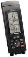 | Magellan's Map 410 receiver includes maps of major roads and waterways, and it can be used in a car, on a boat or on foot. It's priced at $349. |
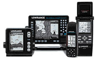 | Lowrance's GlobalNav and GlobalMap products use 12-channel parallel receivers that range in price from $199 to $650. |
| Type of unit. GPS receivers are designed for specific tasks. As standalone units, they can be handheld or mounted on the dashboard of a boat or car. Others are designed as attachments to a laptop computer, a handheld computing device or integrated into a car stereo. Marine units, on the other hand, frequently combine GPS and sonar data. Determining the exact purpose of the application lets the purchaser obtain the best value for the money. Screen resolution. Inexpensive handheld units generally offer screen resolutions of 64 by 100 pixels while a top-of-the-line unit, such as the Magellan NAV 6000, offers 240- by 320-pixel resolution, though at three times the cost. Differential GPS. DGPS offers a much higher degree of accuracy than standard GPS but is more expensive. If the unit is to be used for hiking in the Mojave Desert, 100-meter accuracy is close enough. If it needs to provide driving directions in Manhattan, however, 100 meters would not be close enough to pinpoint which street the user is on. A DGPS receiver should be purchased where accuracy is critical. Back tracking. This allows users to retrace the steps they have taken without having to reprogram the path as a new destination. This feature takes people who are lost back to their last known location. Background maps. The maps permit users to relate their position to the surroundings. Some units come pre-loaded with maps, while other products must upload maps from either a CD-ROM or a data cartridge. Type of receiver. There are two types of receivers: 12-channel parallel and multiplexing. Twelve-channel parallel receivers lock on to and simultaneously receive information from four satellites. The other channels are used to receive and store information from other visible satellites in case one signal is blocked by a building, mountain or heavy foliage. Multiplexing receivers receive data from one satellite at a time and then average the results to determine the position. They are less expensive than parallel receivers, but are slower, less accurate and more subject to the problems caused by signal blockage. |
Ready for service
www.baylor.edu/~grass
www.randmcnally.com
Hold this
| Ashtech Inc. Sunnyvale, Calif. tel. 408-524-1460 www.ashtech.com Ashtech is a subsidiary of Magellan Corp. but continues to make and market products under the Ashtech name. It produces a range of products, including high-end receivers used in surveying, navigation, mining and agriculture. The company's new Micro-Z Continuous Geodetic Reference Station System provides high-accuracy referencing in scientific, land survey, geographic information system and engineering applications. Eagle Electronics Inc. Catoosa, Okla. tel. 800-324-1354 www.eaglegps.com Eagle Electronics offers a line of handheld products, including the $179 Explorer and $419 Map Guide Pro and the $299 marine-mount Eagle View. The $579 AccuMap 12 has a 160 by 160 pixel back-lit screen, a built-in background map of the world and enough memory to save up to 1,200 position points. Garmin International Inc. Olathe, Kan. tel. 913-397-8200 www.garmin.com Garmin has a full line of GPS products, including handheld, marine mount, auto mount, aviation and surveying. Handhelds range from the $195 small, light, monochrome eMap to the $546 NavTalk, which has 100- by 160-pixel resolution. The company's NavTalk Pilot combines a GPS mapping system with a cell phone equipped with an electronic phone book and air-to-ground, ground-to-air and air-to-air calling. | Lowrance Electronics Inc. Tulsa, Okla. tel. 918-437-6881 www.lowrance.com Lowrance has a line of handheld products with 12 channel parallel receivers and from 2,000 to 3,000 track log points. The $180 GlobalNav 12 has a screen resolution of 100 pixels by 65 pixels; the $590 GlobalMap 12 has 160- by 160-pixel resolution. The company also has a range of marine mount devices. Magellan Corp. Santa Clara, Calif. tel. 408-615-5100 www.magellangps.com Magellan has a broad range of 12-channel parallel GPS devices for almost any use, from handheld and marine mount equipment to wireless communication devices for mobile asset and fixed-site tracking. The GPS 300 is the least expensive, at $99. The Map 410, which, like Magellan's other devices, features 10-meter accuracy, has built-in maps of highways and major roads and nautical guides for the Americas and can be used in a car, a boat or on foot. Trimble Navigation Ltd. Sunnyvale, Calif. tel. 408-481-8000 www.trimble.com Trimble makes a broad range of receivers and other devices, including handheld devices for outdoor use and surveying and engineering receivers. |
Drew Robb of Tujunga, Calif., writes about information technology.