GPS products find a way to get you there


A Global Positioning System unit got me to 38 degrees, 50 minutes north and 77 degrees, 45 minutes west on time.
| SPECIAL TO GCNA Global Positioning System unit got me to 38 degrees, 50 minutes north and 77 degrees, 45 minutes west on time.I was driving with a friend from Washington to a festival in The Plains, Va. We took no paper road map, and we knew only vaguely that we should head west.I reached for one of the four GPS receivers I happened to be testing for the GCN Lab'the handheld Magellan Map 330'and oriented it to our current location, which was remarkable considering that we were in a car barreling down the highway.Sure enough, The Plains appeared in the preinstalled list of locations. The Map 330 set up a 'Go to' route and delivered our latitude and longitude as well as bearing, speed, estimated time of arrival and distance.All of that was interesting, especially the ETA and distance, but what we were most concerned about was finding the place. The map unfortunately wasn't very detailed, although the detail that appeared was accurate. It didn't cover the back roads we eventually had to take. The directional cursor on the map page did, however, orient us when we got hopelessly turned around at one point.The ETA and distance were off by quite a bit. The Map 330 said the trip would take us about an hour and a half. Even after getting lost, we drove for only 45 minutes. The 330 also thought The Plains was about 13 miles farther from Washington than was the case, possibly because the device was measuring to the town center, not to the festival fairgrounds.On the way home, however, the Magellan unit proved almost useless. It could no longer locate its directional satellites, although it had no trouble finding them on the way to the festival. I turned the GPS function off, which made the Magellan little better than a compact road atlas.For this review, I tested one other handheld GPS receiver, the Garmin eTrex Vista, as well as DeLorme's Earthmate Road Warrior Edition and Rand McNally's StreetFinder Deluxe, which both work in conjunction with notebook PCs.Of the two handhelds, I found the $350 Garmin eTrex Vista better overall'easier to learn, broader in map detail, better in its interface and physically more elegant than the Magellan Map 330.The eTrex was about the size of a wireless phone and at first glance could easily be mistaken for one. It ran on two AA batteries and weighed five ounces. The thing that gave it away as not being a phone was the absence of a heavy battery.The slightly larger Magellan Map 330 also ran on two AA batteries. Their screens were about the same size, and the two units organized trip data similarly. Both had interfaces consisting of a series of screens showing different trip information.The Map 330's satellite screen mapped out the satellites used in determining location, the signal strength of each satellite and the amount of battery power remaining.One drawback I found with the Map 330 was that it had drained to half power by the time we reached The Plains. It had barely been out of the box three hours, and the specifications stated 10 hours of usable power.On the other hand, the Map 330 had a definite advantage in locating satellite signals while indoors or under cover'something the Garmin unit couldn't do as well.Another Map 330 advantage was clear labeling of controls at the front of the unit. The eTrex controls were on the side and had somewhat cryptic icons instead of labels. That forced me to read the manual carefully, and I got confused trying to figure out which button did what.Both units could store 500 waypoints and 20 reversible routes. But the eTrex had 24M of internal memory, whereas the Map 330 had only 8M, expandable to 16M.The extra memory let Garmin's unit store, in addition to fairly detailed road and trail maps, information about nearby highway exits, shops, gas stations and hotels. It updated them continuously while moving.On a trip back from the Quantico, Va., area, the Map 330 kept track of my approximate location on I-95 and I-395, but the eTrex also gave me a drop-down menu of nearby exits and services available at each.Besides map and satellite screens, the Map 330 had two trip screens for distance, heading, bearing and ETA in slightly different formats. I could customize these fields for more specifics, such as estimated time en route and course to steer.It was fairly straightforward to program a destination and design a route on the Map 330 before departure. But the manual did not go into as much detail as it should for first-time GPS users. Navigating through the various screens and menu options was very easy, however.The eTrex had a similar route setup, although the controls'including a mini-joystick to maneuver between menu options'weren't as easy. But the graphics were far superior despite the slightly smaller screen.Handy as these devices were, I couldn't recommend them for business use. They were extremely portable and sturdy enough to survive, unscathed, a couple of weeks jouncing around in my bags and computer cases.The DeLorme Earthmate Road Warrior and the Rand McNally StreetFinder, both GPS receivers with mapping software for notebook PCs, performed essentially the same functions but with broader capabilities. Designed for business travelers, they had similar interfaces and functions.The DeLorme Road Warrior software required a notebook with a 150-MHz or faster processor, 32M of RAM, at least 270M of free storage, and Microsoft Windows 95 or a later operating system.An optional voice navigation system, which I did not test, required an additional 22M of storage and a close-talk microphone.Loading the DeLorme software onto my Toshiba Portege 7200 notebook was fairly painless. Initializing the GPS receiver also went smoothly'it required only hooking up cables, clicking the appropriate menu items and taking the whole contraption outside to find the satellites.After enjoying the portability and compactness of the handheld devices, however, I couldn't adjust to toting around a much more bulky notebook while it was running. This type of product would not suit field workers unless they habitually carry along an operating notebook.DeLorme recommended trying its tutorials first, which was a necessity in the absence of a user manual. Navigating through the main window was pretty simple. Most of the screen consisted of the active map and navigation tools. There also were links for the trip computer and GPS functions.DeLorme provided lots of options for moving around the map, from simple zoom buttons to address locators.A query button let me point the mouse at map features for information. It gave addresses of business and service establishments, main phone numbers and other information, even local radio stations.But the information in the software was only as accurate as the last update, and it seemed more accurate about larger, more established businesses than smaller ones.DeLorme's NetLink feature can update the stored information as well as get weather data and road construction schedules.Rand McNally's StreetFinder was organized in much the same way. Its screen was slightly easier to figure out the first time, and I recommend it to first-time GPS users.StreetFinder required a notebook with Win95 or a later version, 16M of RAM and 125M of available storage. It took less than a minute to install and about as long to locate the satellites once I hooked up the accompanying receiver and turned it on from the software menu.The GPS function had several views, including a compass, a trip computer and a screen for kids. That last feature made it pretty clear that Rand McNally's product is meant primarily for vacationers, but there were features for business travelers, too.The Concierge tool searched for restaurants, hotels, services and nightlife in a specified area. It could give either driving or walking directions and find exact addresses, as well as specific intersections. It could also search by the name of a location, for example, the White House.I could add addresses directly to an address book from the Find menu, an option not covered in the tutorial but easy to figure out while using the software.StreetFinder, like DeLorme's Road Warrior, had a pull-down menu to get information about specific locations on the main map from the software's database.StreetFinder didn't list as many locations as the DeLorme maps, but every link did have guidebook-style information. The Nearby Attractions feature wasn't very helpful, however. A search for banks, gas stations, grocery stores and hospitals within a five-mile radius of a Foggy Bottom neighborhood in Washington'and there are several of each'turned up no results.On the other hand, the Concierge utility, which presumably accessed the same database, found all the banks, hospitals, pharmacies and post offices within a mile, including some I didn't know about.One glitch in both programs was recognizing certain Washington addresses. Neither would accept specific addresses such as 2100 M St. NW. DeLorme's software didn't recognize D.C. addresses at all until I deleted the street direction indicator and typed in 'Washington,DC' with no space after the comma. That brought up a list of several M streets'NW, NE and SW.Rand McNally's software didn't like the NW, either. I had to leave the city field blank and choose D.C. from a pull-down state menu.Neither glitch would be a deal-breaker, but they're something to check before buying.The GPS functions in both products worked in the same manner. Both had icons to indicate direction taken and satellite strength. Both had a trip computer for planning routes, indicating distance off course and so on.One nice feature about the DeLorme system was that the location arrow on the main map window was also a satellite strength indicator. It glowed green for a strong signal, yellow for seeing fewer than four satellites, and red for a poor signal.I got a red signal twice while driving, and both times all I had to do to fix it was move the receiver a little forward on the dashboard.The DeLorme system took about three minutes to initialize the first time and never more than a minute after that. Rand McNally's system was a bit faster initializing and acquiring signals, but sometimes it had more problems finding a decent signal.Overall, the Rand McNally StreetFinder was easier to learn and use. At $99, it's also more economical. But if you're interested in getting the most possible information, DeLorme's Earthmate Road Warrior is probably the better choice.The big advantage of PC-based GPS units over handhelds is the amount of data they accommodate on more readable notebook screens. The big disadvantages are the lack of portability and the inconvenience'not to mention danger'of trying to type in a moving vehicle.Do not attempt to drive and read about your trip on screen at the same time. That's what passengers are for.
Four receivers are put to the test; notebook-based StreetFinder earns top grade, is easy to install and excels for novice users
BY HEATHER S. BRADY
Hold this one
At the controls
Updates and more
Heather S. Brady is a Washington free-lance reviewer.
BY HEATHER S. BRADY
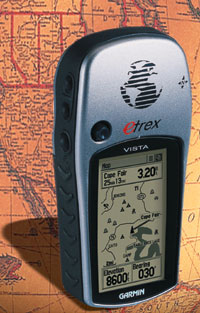 | The eTrex Vista runs on two AA batteries and features broad map details. It's priced at $350. |
Hold this one
At the controls
Updates and more
 |
Heather S. Brady is a Washington free-lance reviewer.
 | StreetFinder Deluxe | eTrex Vista | Earthmate Road Warrior Edition | Map 330 | |
| Vendor | Rand McNally & Co. Skokie, Ill. tel. 800-275-7263 www.randmcnally.com | Garmin International Inc. Olathe, Kan. tel. 913-397-8200 www.garmin.com | DeLorme Yarmouth, Maine tel. 207-846-7000 www.delorme.com | Magellan Corp. Santa Clara, Calif. tel. 408-615-5100 www.magellangps.com | |
| Carrying weight | Depends on notebook | 5 ounces | Depends on notebook | 7 ounces | |
| System requirements | Win95, 16M of RAM, 125M of storage, CD-ROM drive | Self-contained | Win95, 32M of RAM, 270M to 390M of storage, CD-ROM drive | Self-contained | |
| Memory | ' | 24M | ' | 8M | |
| Receiver | 12 channels | 12 channels | 12 channels | 12 channels | |
| Accuracy | Not specified | Less than 10 meters | 15 to 60 meters | Less than 15 meters | |
| Pros | + Low cost, easy to learn + Lots of data available | + Good interface + Lots of map detail + Easy to learn | + Detailed maps, clear tutorials + Strong signals | + Strong signals + Accurate maps + Clear controls | |
| Cons | - Inconsistent success with data searches | - Confusing hand controls - Sometimes poor reception | - Difficult for GPS novices to learn | - Little map detail - Short battery life | |
| Price | $99 | $350 | $180 | $249 | |
| Overall Grade |  |  |  |  | |
NEXT STORY: Ergonomic products find the comfort zone