Raleigh turns to a digital twin to improve city safety and planning

Westy72 via Getty Images


The North Carolina city is leveraging digital twin technology to help inform traffic management and city planning decisions.
In North Carolina, cities like Raleigh are some of the fastest growing communities across the nation. One way city leaders are innovating how they better serve that growing population is through the development of a digital twin of Raleigh, which could help improve community safety and interagency collaboration, one official says.
The city of Raleigh’s population surpassed 500,000 people last year, following an increase of 32,728 people from April 2020 to July 2024, according to state data.
That means more people driving on the roads and crossing streets everyday, and that “population growth puts a lot of pressure on the local government to continue to deliver the services that make the area attractive to our citizens and new residents,” said Jim Alberque, GIS and emerging technology manager for Raleigh.
Tech and data are a “key piece” to do that and “with the advancements in technology, specifically in the areas of [artificial intelligence], the opportunities for us to better understand our city has never been better,” he said.
Over the last two years, Raleigh has been developing a digital twin of the city with the ultimate goal of optimizing traffic management and enhancing transportation safety, Alberque said.
The digital twin uses traffic data collected by the city’s cameras installed at certain intersections, and AI technology from NVIDIA identifies and tracks the movement of vehicles, bikes, pedestrians and micromobility devices like scooters, he explained. Raleigh is also leveraging Esri ArcGIS and Microsoft Azure platforms to visualize and map the near real-time data on traffic flow and events.
The digital twin serves as a computer-vision model of the city that can be used by city planners and transportation leaders to identify areas where traffic incidents, like increasing congestion or accidents, occur to inform efforts to address such issues like implementing dynamic traffic signaling, Alberque said.
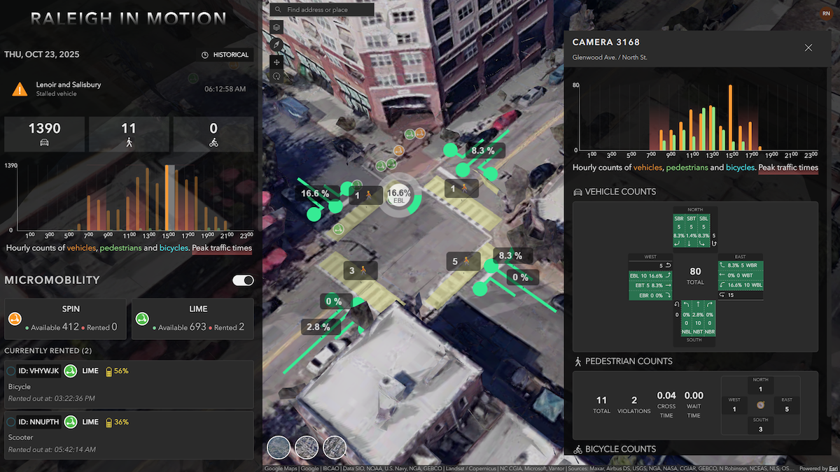
Currently, the digital twin has been applied to 12 intersections in Raleigh, but officials plan to scale it citywide as the technology matures, he said. A long-term goal for the city is to leverage the digital twin to enable data-sharing across transportation and public safety agencies by, for instance, detecting an accident somewhere in the city and automatically alerting law enforcement to the situation.
City officials are also considering how the digital twin can be leveraged for strategic infrastructure planning, such as determining where bike lanes or bus stops can be installed efficiently and safely based on traffic trends.
That kind of scenario planning could also assist city planners’ bigger projects, such as constructing a new building in the city, Alberque explained. The digital twin can provide projected insights such as how the building could impact surrounding traffic conditions or government services, like the routes of waste management vehicles.
Municipalities are increasingly exploring the innovative technology as a tool to improve city planning, allocate resources more efficiently and improve cost efficiency.
Phoenix, for example, is considering how a regional digital twin could help enhance traffic, development and climate challenges. In south Texas, law enforcement are leveraging a digital twin to monitor the safety and security of the Port of Corpus Christi.
“The world is a complex place, and modeling it is really hard,” Alberque said. “I believe that we are getting close to a world where technology can get pretty close to modeling the complexity of the world, and then once we can start to understand [it], we can … provide insights to practitioners and decision makers to allow them to make tactical and strategic decisions with this data.”